Spratlys > Islands Names
1935 Names of South China Sea Islands
1. Historical background on the 1935 South China Sea Names:
Following Paragraphs are from the following paper:
"In January 1930 the Chinese government promulgated The Inspection
Regulations of Land and Water Maps (Shuilu ditu shencha tiaoli). Consultation
between the Ministry of Internal Affairs, the Foreign Ministry, the Marine
Ministry, the
Ministry of Education, and the Committee of Mongolia and Tibet led to
an extension
and revision of the above regulations in September 1931 with The Revised
Inspection
Regulations of Land and Water Maps (Xiuzheng shuilu ditu shencha tiaoli).
Following
further consultations, a Land and Water Maps Inspection Committee, whose
members
were representatives sent by the relevant institutions and departments,
was formed and
started work on June 7, 1933.
The Land and Water Maps Inspection Committee made significant contributions
to
the defense of China’s sovereignty in the South China Sea. At the
25th meeting held on
December 21, 1934, the Committee examined and approved both Chinese and
English
names for all of the Chinese islands and reefs in the South China Sea.
In the first issue
of the Committee’s journal published in January 1935, they listed
the names of 132
islands, reefs, and low tide elevations in the South China Sea, of which
28 were in the
Paracel Islands archipelago and 96 in the Spratly Islands archipelago.1
At the 29th meeting
held on March 12, 1935, based on the various questions raised by the Ya
Xin Di
Xueshe, the Committee stipulated that “except on the large-scale
national administrative
maps of China that should delineate the Pratas Islands, the Paracel Islands,
the Macclesfield
Bank and the Spratly Islands, other maps need not mark or note these islands
if the
locations of the islands were beyond the extent of the maps.”2[See
Shuilu ditu shencha weiyuanhui huikan [Journal of Land and Water Maps
Inspection
Committee], Vol. 3 (September 1935): 79–80.]
The Map of Chinese Islands in the South China Sea (Zhongguo nanhai daoyu
tu)
published by the Committee in April 1935 declared that China’s southernmost
boundary
should reach the 4º northern latitude. Thus the James Shoal was marked
as being within
the Chinese boundary. On the second map, The Map of Chinese Domain in
the South
China Sea (Haijiang nan zhan hou zhi zhongguo quantu) in the book The
New Map of
Chinese Construction (Zhongguo jianshe xin ditu), edited by Bai Meichu
in 1936, the
Pratas Islands, the Paracel Islands, the Macclesfield Bank, and the Spratly
Islands were
drawn as being within Chinese territory in the South China Sea. The boundaries
of the
islands were marked by national boundary lines showing that these islands
belong to
China. The southernmost national boundary line of the South China Sea
Islands area
was indicated as being the 4º northern latitude. The James Shoal
was indicated as being
within the national boundary. In the annotation of the map, the mapmaker
states:
The six isles occupied by France in July 1933 together with the Macclesfield
Bank and the Spratly Islands measured afterwards by the Nautical Bureau of
the Marine were the living places of Chinese fishermen. The sovereignty, of
course, belonged to China. In April 1935, the Chinese Central Inspection
Committee of Land and Water Maps issued The Map of Chinese Islands in
the South China Sea (Zhongguo nanhai daoyu tu) in its journal. The southern
coastal areas extended to the James Shoal in the Spratly Islands, which
was just at the 4º northern latitude. This was China’s southernmost coastal
boundary in the South China Sea.3[Han Zhenhua (ed.), Woguo nanhai zhudao shiliao huibian [The Compilation of Historic
Materials on the South China Sea Islands], (the Oriental Publishing House, 1988), 360.]
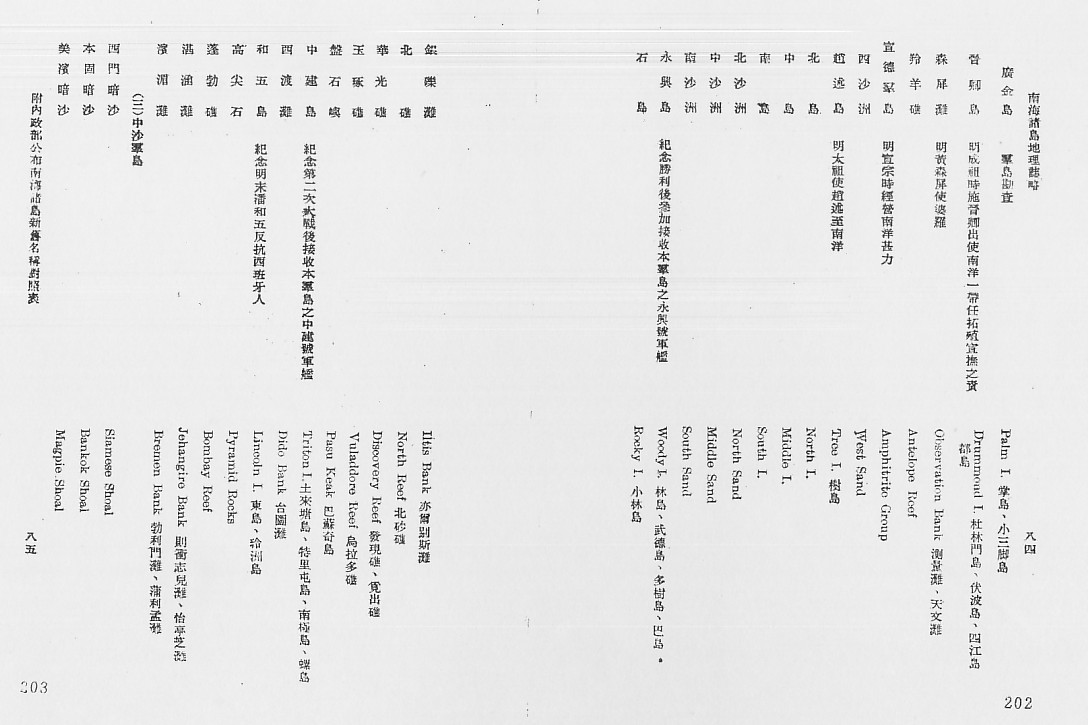
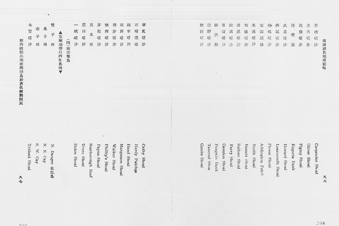
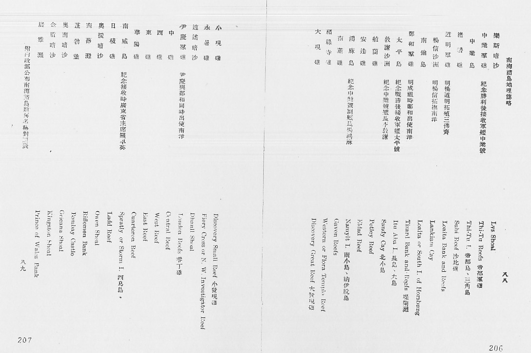
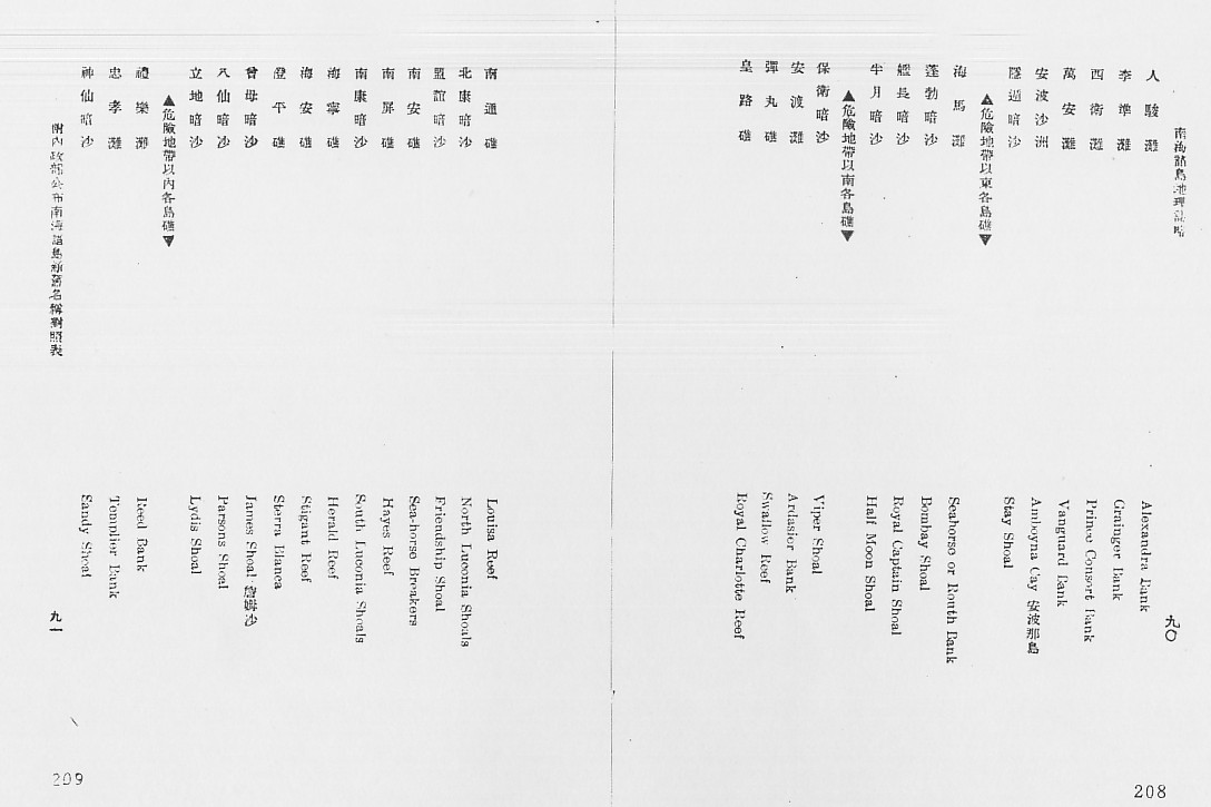
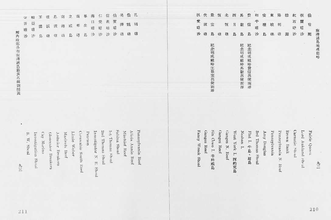
2. The following list shows both the 1947 Revised Names (at the top part of each page) and the 1935 Names (at the bottom part of each page). Besides that, the list below also gives the meanings of the names given to these South China Sea islands.
- 政资约:《南海诸岛地理志略》,1947
(Zheng Ziyue, Nanhai Zhudao Dili Zhilue, [South China Sea Islands
Geological Records/Annals], 1947)


3. Please view the Map of Chinese Islands in the South China Sea (Zhongguo nanhai daoyu tu) published in 1935 under Spratly Islands Maps.